Geophysical Surveys
Project being finalized
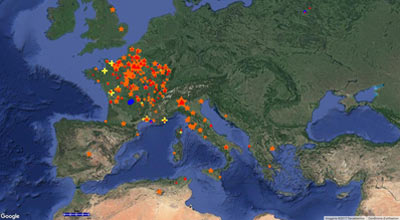
This project aims at making the exhaustive inventory of all the surveys undertaken by both leading companies specialized in the detection and the mapping of archaeological sites (Terra Nova and Géocarta). This inventory includes 463 operations covering the period of 1995 at the end of 2016. Most of the operations are located in France and in Italy. Every operation can be located with a resolution at the level of the municipality or even more exactly at the level of the plot (cadaster). The database contains besides the type of used method (electric, magnetic, low frequency electromagnetic prospecting, GPR), the date of the beginning of the survey and a general comment. The reports of the operations are not in this base, but the date of survey allows to find them easily.
The maps generated show the distribution of the surveys superposed on a layer which can be IGN portal (orthophotos and cadastral plots), or Google Earth. A second series of maps shows the type of method used with a symbology linked to the area surveyed. Finally, specialized maps were produced such as the one for the research field of Garden Archaeology.
See on you tube :
Radiographie des villages gaulois, de la prospection à la fouille